Bassett Hall Historical Report, Block 1 Building 22Originally entitled: "Bassett Hall Block #1"
Colonial Williamsburg Foundation Library Research Report Series - 1004
Colonial Williamsburg Foundation Library
Williamsburg, Virginia
1990
BASSETT HALL
Block #1
BASSETT HALL
Block #1
LOCATION:
Bassett Hall is located south of Francis Street near the Capitol.
HISTORY:
The well known lots in Williamsburg now called "Bassett Hall," were a part of a large acreage owned by the Bray family in the early eighteenth century. About 1750 the tract comprised about nine hundred and fifty acres in James City County, and four lots in Williamsburg. These lands lay to the south, and southwest of the Capitol; and to the back of Francis Street, adjoining the "Tazewell Hall" tract. A chain to title can be traced to the present time and will be given below.
Although many of the records concerning the property were lost with the destruction of the James City County Records in the Civil War, a few relating to the Bray ownership have survived.
Records of the property from 1751 to 1865 show that the land had become involved in an entailed estate, mortgages and deeds of trust. Records of the entail and the manner of settling the debts of the property owners, are recorded in Hening's Statutes at Large; in the Virginia Gazette; and in manuscript papers at the College of William and Mary.
On November 5th and 6th, 1751, John Blair made the following comment in his Diary:
5 —
Mr. Johnson1 has 9 months given him to consider if he will prosecute his appeals agt Judy Bray Ingles,2 2 and agt Col. Bray's1 execrs for the 2 moitys of Nances Neck2 and Tuttys Neck, but this by consent of partys.6.
(Diary of John Blair, copied from an Almanac 1751, William and Mary Quarterly, Series I, VIII, 14.)
Mr. Johnson's bill in equity against Bray's execrs was red by the court.
A legal disagreement between Colonel Johnson and the other Bray heirs came to a settlement, doubtless, in 1753. In November Philip Johnson came into possession of the tract of 950 acres thereabout known in later years as the "Bassett Hall lands." According to the terms of entail, the land described above should come into possession of James Bray and his male heirs. If James Bray had no sons, then the property was to be divided equally between the heirs of James Bray and the lawful heir of his sister, Ann Inglis, wife of Mungo Inglis. Thomas Bray, James Bray's eldest son, entered the land and died seised of it, leaving no male heir. However, Bray had a daughter, Elizabeth, wife of Philip Johnson. At a General Court in Williamsburg, October 11, 1752, in a chancery suit between Johnson, plaintiff, and Benjamin Waller and William Prentis, defendants, it was ordered by the court that Waller and Prentis convey unto John Robinson3 and his heirs - all the lands and slaves devised to them by Thomas Bray in trust as to one moiety for Philip Johnson during his life, and after his decrease to his children. The result: the lands adjoining Williamsburg in James City County and the two lots between the lots of Benjamin Harrison and Benjamin Waller were awarded to Philip Johnson. (See: An Act … concerning lands in James City and lots in Williamsburg in Hening's Statutes, VI, 412-416, copy in Illustration #1.)
3Johnson's plantation is cited in the Virginia Gazette of date, April 4, 1755:
NOTICE is hereby given; THAT there is a good Stable and Pasture, with all Sorts of Provinder for Horses, at the Plantation of Philip Johnson, near the Capitol in Williamsburg; where Gentlemen may depend on having proper Care taken of their Horses, Carriages, &c.(Virginia Gazette, Hunter, ed., April 4, 1755.)
There is no mention of a dwelling-house. Neither can the bounds of the plantation be defined. However, from the record (as reported in Hening), it is certain that Johnson's plantation comprised a part of the Bray lands which had come by entail to his wife, Elizabeth Bray Johnson.
In 1758 certain lands of Philip Johnson were vested in John Robinson, in trust:
… Be it therefore enacted, by the Lieutenant-Governor, Council, and Burgesses, of this present General Assembly, and it is hereby enacted, by the authority of the same, That the said seventeen acres and twenty-six poles of land, adjoining the southern bounds of the said city of Williamsburg shall be, and the same are hereby vested in the said Philip Johnson, his heirs and assigns; and that the said forty-three acres of land, with the appurtenances, lying in the said parish of Bruton, and county of James-City, late the estate of the said John Baskerfield, shall be, and the same are hereby vested in the said John Robinson, his heirs and assigns, in trust, and to and for the same uses that he is and now stands seized of the residue of the said trust lands. (An Act for vesting certain lands therein mentioned in Philip Johnson, gentleman; adding the same to the City of Williamsburg, and for other purposes there-in mentioned — Hening's Statutes, VII, 247 ff; Sept. 1758)
It was further enacted by the authority aforesaid "That the said seventeen acres and twenty-six poles of land, so laid off by the said Philip Johnson into [thirty] lots, adjoining the said city of Williamsburg, so soon as the said lot shall respectively be built upon, and saved according to the conditions that shall be contained in the deeds of conveyance thereof, shall be added to and made part of the said city …" (Ibid.,> 248)
Under the conditions of conveyance, houses of some nature must be 4 built upon the land. Johnson1 was given the nineteen acres and twenty-six poles of land in fee simple; and the forty-three acres of land with the appurtenances… "late the estate of John Baskerfield2 contiguous to the nineteen acres and twenty-six poles were vested in John Robinson in trust … for the uses that he is and now stands seized of the residue of the trust land." (Hening, VII, 453, March 1761.)
By 1766 Johnson had become heavily involved in debt. His houses and lots adjoining Williamsburg were advertised for rent:
TO BE RENTED June 6, 1766. THE houses, lots, gardens, stable, and pasture, where I lately lived, adjoining the City of Williamsburg, Any person inclinable to rent them for a year, or term of years, may know the terms by applying to Doctor Hay, or Philip Johnson. (Virginia Gazette, Purdie & Dixon, eds.)
There appeared in the Virginia Gazette of April 14, 1768 the following notice from Johnson:
THIS is to request the favour of all my Creditors to meet me at the brick house of Mr. Gabriel Maupin, in Williamsburg, the second day of next month…(Virginia Gazette, Purdie & Dixon, eds.)
Philip Johnson
As John Robinson, trustee of the lands of Johnson, had died by November, 1769, other trustees were appointed to hold the monies and property. According to Bray's will, Philip Johnson, his son-in-law, would have a life right after the death of his wife, Elizabeth.3 These lands described were:
… one messuage, and three hundred and twelve acres of land, adjoining the city of Williamsburg, except nineteen acres, and twenty-six poles, laid off into lots, and annexed to the city of Williamsburg, by an act made in the first year of the reign of his present majesty … also forty-three acres, purchased by 5 Philip Johnson, gentleman, of John Baskerfield, also of six hundred acres, with the appurtenances, called and known by the name of Tutty's Neck, and also of two lots or half acres of land on Francis street, in the city of Williamsburg, situate between the lots of William Pasteur1 and Benjamin Waller, gentlemen, in trust, as to one moiety thereof for the use of Philip Johnson, gentleman, during his natural life… (Hening's Statutes, VIII, 460-61)
By 1771 Colonel Johnson had rented his house in the city:
WILLIAMSBURG, March 7, 1771.
THE Subscriber begs Leave to acquaint the Gentlemen who favoured him with their Custom that he is now removed to Colonel Johnson's house, behind that of Mr. Waller; where they may depend upon the best Accommodations for themselves, Servants, and Horses.
(Virginia Gazette, Purdie & Dixon, eds.)
RICHARD HUNT SINGLETON.
In the advertisement, Colonel Johnson's house is described as "behind that of Mr. Waller."2 Benjamin Waller's residence was located on Francis Street just below the Capitol. The present Bassett Hall is situated to the southwest of the Waller house; which fact leads one to assume that Philip Johnson had built on the site before 1771. The following notice confirms the above statement:
WILLIAMSBURG, OCTOBER 1, 1771.
PURSUANT to a late Act of the General Assembly, which hath received the Royal Assent, we propose to sell to the highest Bidders, on Thursday the 31st Instant, at four o'Clock in the Afternoon, before Mr. Southall's door, in this City, the DWELLING-HOUSE, OUTHOUSES, GARDEN, and PASTURE, where Colonel Philip Johnson formerly lived, now in the Tenure of Mr. Richard Hunt Singleton; also the Remainder of the same Tract of LAND Adjoining the City of Williamsburg, with two LOTS on Francis Street, between the LOTS of Mr. Waller and Doctor Pasteur; the whole to be disposed of together, or in Parcels, as may best suit the Purchasers.
At the same time will be sold a Tract of LAND called Tutty's Neck, containing about six Hundred Acres, more or less, very convenient to the City of Williamsburg, whereon are all necessary Houses for Cropping. Two Years Credit will be allowed the Purchasers upon their giving Bonds, with approved Security, payable with Interest from the 6 Dates.
PEYTON RANDOLPH
(Virginia Gazette, Purdie & Dixon, eds., Oct. 3, 1771.)
RO. C. NICHOLAS Trustees.
LEWIS BURWELL
PHILIP W CLAIBORNE
In this notice the property of Colonel Johnson is clearly defined: two lots on Francis Street, a dwelling and outbuildings, and about six hundred acres called "Tutty's Neck," and the remainder of the dwelling-house tract.
Another notice from the Trustees of Johnson's property sheds light on the situation:
WILLIAMSBURG,
November 21, 1771.THE Trustees, not thinking it proper to proceed on the Sale of Colonel Philip Johnson's Land, near this City, on the 31st of October, last, according to their former Advertisement, without an exact Survey of the valuable Tract called Tutty's Neck, and having the Land contiguous to the Town laid out in small Parcels, now give Notice that they intend to sell those lands on Tuesday the 10th of December, at four o'Clock in the Afternoon, before Mr. Southall's Door; when the plan of the Survey and Division will be shown to any who are inclined to buy. The Purchasers will be allowed two years Credit; and it is expected they are to give Bonds, with unexceptionable Securities, which are to carry Interest from the Time they bear Date.
(Virginia Gazette, Purdie & Dixon, eds.)
PEYTON RANDOLPH
RO. C. NICHOLAS Trustees.
LEWIS BURWELL
PHILIP W CLAIBORNE .
Though effort had been made by the Trustees, no sale had been completed in January, 1772. Singleton was, apparently, renting the Johnson property:
7WILLIAMSBURG,
January 27, 1772.THE Subscriber begs Leave to inform the Publick that he still continues to occupy the House, on the South Side of the Capitol, where the Gentlemen Burgesses may depend upon the best Treatment, on the most reasonable Terms, from Their very humble Servant,
RICHARD SINGLETON.N.B. Good stables, Pastures, &c.
(Virginia Gazette, Purdie & Dixon, eds.)
The dwelling-house of Colonel Johnson had not been sold in April, 1773:
To be SOLD, on Friday the30th Instant (April) at five o'Clock in the Afternoon, before Mr. Southall's Door, in Williamsburg,
The Dwellinghouse, Outhouses, Lots, and Pasture, where Colonel Philip Johnson formerly lived, in this City. The Commodiousness of their Situation need not be described, as it is so well known. Any Person inclining to purchase may in the mean Time treat with Peyton Randolph and Robert Carter Nicholas, Esquires. The Lenement may be entered upon immediately, and the Purchaser, will have Credit till next Christmas, paying Interest from the Day of Sale, and giving Bond, with approved Security. (Virginia Gazette, Purdie & Dixon, eds.)
In October, 1773, Colonel Johnson was serving as justice of James City County. (Ibid.) A runaway who was the property of Johnson had been hired to Thomas Skinner by the trustees for almost four years. In October 1774, Skinner sent notice that he suspected that the runaway was harbored at one of Johnson's quarters. The trustees of Johnson's property were still in power at this date.
Colonel Johnson resigned in 1776 as county lieutenant of James City on account of age and infirmaties. (Journal of the Council of Virginia, I, 254.) He had served also as a member of the committee of safety. (William and Mary Quarterly, V, 104.)
The property of Johnson had not been sold in 1777.1 Effort was still being made by the trustees to pay creditors: 8
WILLIAMSBURG,
THE Trustees of Col. Philip Johnson being anxious to settle his Affairs, and having good Prospect of paying in a short time, the Demands of such of his Creditors as acceded to the Deed of Trust, desire a meeting of those Creditors at the House of Mr. James Southall in this city, on Thursday the 13th of March next. If any of them should be unable to attend, they are requested to send their claims properly stated. — All those indebted to the Trust Estate for the Hire of Negroes, or other wise, are desired to make immediate Payments to Mr. John Watkins of King William County, who will attend here the same Day. No indulgences can be given.
February 26, 1777.
THE TRUSTEES. (Virginia Gazette, Dixon & Hunter, eds.)
On the Galt Map (1780?) Johnson's land lies to the east of Tazewell Hall. On Rochambeau's Map (1782) of this area, Johnston's Mill1 is situated to the southeast of King's Mill. On the Frenchman's Map (1782) the dwelling house, rectangular in shape with rear wing, is placed about 400 feet from street [Francis street]. There are three out-buildings about 50 feet to the rear, and 2 out-buildings in right-rear and left-rear about 25 feet and 350 feet, respectively, from the dwelling. The dwelling sets about 500 feet from the Waller house. A rectangular-shaped yard is about 400 feet by 200 feet with a small building in the northwest corner on the street. The out-buildings are not inclosed in the 250 by 200 feet area. (See: architect's drawing from the Frenchman's Map, Illustration #3) Also included in Illustration #3 is an archaeological report by Herbert S. Ragland, 1932, concerning the old foundations found on the property.
The land tax records for James City County indicate that Philip Johnson paid taxes in 1787 on 204 acres of land at 9/8 per acre; valued at $98.12. (Illustration #2)
In December 1788, it became necessary to appoint other trustees 9 of the Johnson property. (Hening's Statutes, XII, 716-17)
On March 19, 1789 the newspaper reported the death of Colonel Johnson:
DEATHS. Departed this life on the 15th Instant Mr. PHILIP JOHNSTON [Johnson?∥ of James City county. (Virginia Gazette & Weekly Advertiser, Nicholson ed.)
The College Map (1791?) shows Johnson's land to the east of Tasewell's [Tazewell Hall] and south of Hubbard, Waters, Bassett and the Corporation lots. See also Bucktrout Map (1803) for locations. (Research Department has copies of these maps.)
Several deeds to adjoining property around 1800-1806 as well as insurance policies of the Mutual Assurance Society on the Semple property, indicate that Burwell Bassett1 had become the owner of Philip Johnson's lots and lands in and adjoining Williamsburg. A deed from Lewis Saunders to Littleton Tazewell located Bassett on the land formerly owned by Johnson: "…The greater tract by the lands of Burwell Bassett, by those of Littleton Tazewell, by those of Gabriel Maupin decd, and by the Creek which heads near Southall's Mills … being the tract of which the said John Saunders … died intestate, sometime in the year 1793 …" (Southall Papers, College of William, and Mary.) In 1806 an insurance policy of James Semple's gives Burwell Bassett's lot adjoining Semple. (Copy of policy in Research Department.)
The Williamsburg land tax records for 1804 and 1810 give Bassett as owner of 2 lots valued at $20 and $10 respectively. From 1812 to 1820 Bassett is listed as possessing 6 lots valued at $30. From 1820 to 1838 Bassett whose residence is given as "James City," is owner of "1 lot in Williamsburg valued at $75." (Illustration #2 for complete records.)
10The lot listed in the land tax list above, doubtless, was the entrance lot to Bassett Hall by way of Francis Street. From the fact that owners of Bassett Hall paid taxes on lots in the city (adjoining Waller's lots on Francis Street), it seems reasonable to state that such land was used as an entrance park to the Bassett Hall dwelling-house lot.
During 1836-42 a correspondence relating to Bassett Hall property was carried on between Apel P. Upshur1 of "Vaucluse," eastern shore of Virginia, and Judge Beverley Tucker of Williamsburg. From these letters one finds that Upshur became the owner of Bassett Hall on May 5, 1840. (Illustration #5, copies of letters dated Dec. 4, 1840; January 27, 1840; April 5, 1840 and November 28, 1840.)
The property was acquired in 1843 by John Coke. The Land Tax Records give: "1 lot including buildings $2550 via Abel P. Upshur — See an act of Assembly passed, 31st January 1843, which, by extending the limits of the city, a small slip of land theretofore taxed to Colo. Bassett's estate becomes merged in the property purchased by Mr J. Coke of the Hon. Ap. Upshur, who purchased of Galt who purchasd of Bassett."
Coke held the property until November 18, 1845 when it was conveyed to Goodrich Durfey. In 1850 Durfey was charged in the land book with "1 lot valuations with buildings $2550. Formerly ded to John Coke." Durfey in 1861 was charged with "1 lot valued at $3500." (Illustration #2)
Several maps have come to light giving Bassett Hall tract with adjoining lots. One with date on the back, "1868", is of exceptional interest as to locations of houses and farming area. In the lower corner of the map one finds: "Plot of Col Durfeys house tract after cutting of 60.2 & some 11 perches for Mr. Lefelver & contains 381..3..28 perches[,] Map endorsed A on back, by Sidney Smith Trustee and referred to in deed of Z. G. Durfey to Israel Smith. Cut the cloth where paper is slipped under." On the back of the map the following is written: "B This is the plot referred to in the deed from Z. G. Durfey to Israel Smith, executed 15th Decbr 1868, S. Smith sub Trustee." Upon examination of the map one sees a large plat southeast of the dwelling and to the rear of the Waller dwelling marked, "Land sold by Col. Durfey to Mr Lyons." From a study of the map above described, we know that Durfey retained as his dwelling house tract the 85 acres with avenue leading into Williamsburg via Francis Street. (Illustration #3 for copy)
Another map1 with no date is now in the Research Department. It is a colored map of Bassett Hall and surrounding lands. The dwelling is drawn as rectangular with rear wing, facing upon a 2-acre lawn. A circular drive-way is shown in front of the house and a road leads out to Francis Street and to the farm lots in the rear of the dwelling-house. Dr. Morris is noted as the occupant of the Benjamin Waller lot; J. W. Custis3 and Wooden to the west. Farm lands, gardens, orchards, barns, ice house, hog pen, cow yard, pasture — all show on the map to the rear of the dwelling. (Illustration #3 for photostat)
In 1865 the court records of Williamsburg and James City County were destroyed by fire. Only one Deed Book (1854) was saved from destruction. From this book it is possible to trace the title to Bassett Hall.
Upon the death of Durfey in 1869 the property was conveyed to Israel Smith.
12The chain to title as prepared by Mr. Channing Hall for Dr. W. A. R. Goodwin, 1927, can be found in Illustration #4. Dr. Goodwin was representing the interests of Colonial Williamsburg Restoration in securing the property from the owners at that time.
IN SUMMARY:
Bassett Hall comprises a part of that large tract once the property of the Bray family. By marriage to Elizabeth Bray, daughter of Thomas Bray, the lands came into the possession of Colonel Philip Johnson about 1753. The plantation of Philip Johnson is cited in the Virginia Gazette of April 4, 1755 as "near the Capitol in Williamsburg." However, there is no mention of a dwelling-house in this notice. In 1766, "the houses and lots of Johnson adjoining the City of Williamsburg," were advertised to be rented. The Virginia Gazette describes Johnson's property as "the houses, lots, garden, stable and pasture, where I lately lived." By 1771, Johnson had rented his house to Richard Hunt Singleton. Singleton advertised that "The Subscriber begs Leave to acquaint the Gentlemen who favoured him with their Custom that he is now removed to Colonel Johnson's house, behind that of Mr. Waller." (The reference is to Benjamin Waller whose house was on Francis Street just below the Capitol.) An effort was made to sell Johnson's property in October and November, 1771, but no sale was consummated by the trustees until after Johnson's death in March, 1789. On the Frenchman's Map of Williamsburg (1782) the dwelling-house, rectangular in shape with a rear wing, is placed about 400 feet from a street to the north. There are three out-buildings about 50 feet to the southeast, and one to the southwest. Another small building is about 350 feet to the south. A rectangular shaped yard upon which the house faces is about 400 feet by 200 feet with a small building in the northwest corner. The College Map (1791?) indicates "the 13 lands of Philip Johnson" in this area, as does the Bucktrout Map (1803). Several deeds between 1800-1806 and an insurance policy to bordering property, show that Burwell Bassett [of Eltham] had come into the lots and lands of Philip Johnson; and the Williamsburg Land Tax records give Bassett as owner of "2 lots valued at $20 and $10" respectively. From 1820-38 Bassett appears as owner of "1 lot valued at $75." In 1840, Abel P. Upshur of "Vaucluse," eastern shore of Virginia, became the owner of Bassett Hall. In 1843, the records show that John Coke was the owner of "1 lot valued including buildings at $2550 via Abel P. Upshur." In 1845, Goodrich Durfey became the owner of "1 lot valued at $2550 including buildings. Formerly ded to John Coke." In 1869 the property was conveyed to Israel Smith by the executor of Goodrich Durfey. From a study of a map by S. Smith (dated 1868) one sees that Durfey during his tenure, retained as his dwelling-house tract the 85 acres with avenue leading into Williamsburg via Francis Street, and sold other lands adjoining. Another map (no date, but possibly 1869) is a colored map of Bassett Hall and surrounding lands. The dwelling is drawn as a rectangular building with rear wing, facing upon a 2-acre lawn. A circular drive is shown in front of the house, and a road leads out to Francis Street north and the farm lots to the south. Though court records of Williamsburg and James City County were largely destroyed by fire in 1865, one deed book was saved and from this record it is now possible to trace the title to Bassett Hall from Israel Smith's ownership to the present time. Further title to the property as prepared by Channing Hall for Dr. W. A. R. Goodwin representing the Restoration interests in 1927, can be found in Illustration #4, Appendix.
14| Illustration #1 | Abstracts from Hening's Statutes of Virginia |
| Illustration #2 | Williamsburg Land Tax Records |
| Illustration #3 | Maps and Archaeological Reports |
| Illustration #4 | Abstracts to Title |
| Illustration #5 | Historical Material, letters &c. |
| Illustration #6 | List of pictures on file of Bassett Hall |
Report prepared by Mary A. Stephenson
Typed by L.N.M. January 1951
Footnotes
Illustration #1
An Act for establishing an agreement made between Philip
Johnson, and William Armistead, gentlemen.
HeningSTATUTES AT LARGE
VI, 412-416
WHEREAS David Bray the elder, late of the parish of Wilmington, in the county of James City, gentleman, deceased, in his lifetime, and at the time of his death, was seised in fee-simple, of, and in four lots of land in the city of Williamsburg, and several tracts or parcels of land, in the said county of James City, containing by estimation nine hundred and fifty acres, or thereabouts, and of, and in another tract or parcel lying in the county of Charles-City, containing by estimation, eighteen hundred and fifty acres or thereabouts, known by the name of Nance's-Neck; and being so seised, by his last will and testament in writing, bearing date the twenty first day of October, one thousand seven hundred and seventeen, devised all his lands to David Bray his son, and declared his will and meaning to be, that if his said son David should live till he came to the age of twenty one years, and should not have issue of his body lawfully begotten, he should not sell or dispose of any of the said lands, until he had such issue; but if he should live to have such issue of his body, and attain the age of twenty one years, if both the things should happen, he gave his said son all his lands to him and his heirs forever; but in case he should die, before he had lawful issue, he gave all his said lands to his brother James Bray, and the heirs male of his body lawfully begotten, and in default of such issue, declared his will to be, that his said lands should be equally divided between the heirs of his said brother James Bray, and the lawful heir of his late deceased sister, Ann Ingles, late wife of Mungo Ingles, as by the said will, recorded in the court of the said county of James-City, may, among other things appear. And after the death of the said David Bray the father, the said David Bray the son, entered into the said lands, and died seised thereof, without issue of his body; and the said testator's brother James Bray in the said will named died, leaving issue Thomas Bray, his eldest son, and heir male of his body, who after the death of the said David Bray the son, entered into the said lands, and died seised thereof, without heir male of his body, leaving a daughter named Elizabeth, then and now the wife of Philip Johnson, of the county of King and Queen, gentleman, having first made his last will and testament in writing, bearing date the seventh day of May, one thousand seven hundred and fifty one, and thereby devised the remainder in fee-simple, of one moiety of the said lands to Benjamin Waller, and William Prentis, gentleman, in trust, to, and for several uses in the said will mentioned, as by the said will remaining of record, in the court of the said county of James City, may among other things appear. And whereas one Judith Bray Ingles, was heir at law of the said Ann Ingles, the sister of the said David Bray the father, and named in his will, and is intitled to the other moiety of the said lands, and hath lately married one William Armistead, gent. And whereas at a general court, held at the court-house in Williamsburg, the the eleventh day of October one thousand seven hundred and fifty two, in a suit in chancery, between the said Philip Johnson, plaintiff, and the said Benjamin Waller, and William Prentis, defendants, it was decreed and ordered by the said court, 2 that the said Benjamin Waller, and William Prentis, should convey unto John Robinson, esquire, all the lands and slaves devised to them by the said Thomas Bray, to hold to the said John Robinson, his heirs and assigns, in trust, as to one moiety thereof, to, and for the use of the said Philip Johnson, during his natural life, and after his decease, in trust, to, and for the use of such child, or children, as the said Philip then had, or might thereafter have by the abovenamed Elizabeth, his wife, to whom he should give or devise the same; by his deed, will, or other instrument in writing, duly made and executed, and to his, her or their heirs and assigns forever; subject nevertheless, to the dower of the said Elizabeth therein; and as to the other moiety in trust, to and for the use of the said Philip Johnson, his heirs and assigns forever, in case he shall pay unto such child or children, of him and the said Elizabeth, all and every such sum and sums of money, as the said Elizabeth, notwithstanding her coverture, shall by any deed or instsument [sic] in writing, duly executed by her, give, direct and appoint, according to a proviso and his covenant, contained in a certain indenture of release: But in case the said Philip Johnson, shall not pay such sum of money, then in trust, to and for the use of such child or children aforesaid, to whom the said Elizabeth, by such deed or instrument in writing, shall give, direct and appoint the same: And in case the said Elizabeth, shall execute no such deed or instrument, then in trust to and for the use of the said Philip Johnson, during his natural life, and after his decease, in trust, and to, and for the use of such child or children as the said Philip Johnson then had or might thereafter have by the said Elizabeth, to whom he shall give or devise the same, by his deed or will as aforesaid, and to the heirs and assigns of such child or children forever; subject nevertheless to the dower of the said Elizabeth, therein, as by the record and proceedings of the said suit in chancery, remaining in the general court aforesaid may among other things appear: And the said Benjamin Waller, and William Prentis, have accordingly conveyed to the said John Robinson, and his heirs, the said lands and slaves in trust, and to, and for the several uses in the said decree mentioned. And whereas in case partition shall be made of the said lands, between the said Philip Johnson and Elizabeth his wife, and the said William Armistead and Judith Bray, his wife, the value of the said lands will be considerably diminished, and it will be more beneficial to all parties claiming the same, if they shall remain entire; and the said Philip Johnson, and William Armistead, have agreed, that all the said tract of land known by the name of Nance's neck, with the appurtenances, and two of the said lots of land, adjoining the lots of Dudley Digges, gentleman, and James Spiers, in Francis-street, in the said city, shall be vested in the said William Armistead, and Judith Bray his wife, and the heirs of the said Judith Bray; to hold to them in the same manner, and for the same estate, as they would have had and held the moiety thereof, if this act had not been made: And that the other two lots of land lying in the said street, between the lots of Benjamin Harrison, gentleman, and the said Benjamin Waller, and all the said tracts or parcels of land in the county of James City aforesaid, with the appurtenances, shall be vested in the said John Robinson, to hold to him, his heirs and assigns in trust, and to and for the same uses, and in the same manner, as the said John Robinson and his heirs would have had and held one moiety thereof, if this act had not 3 been made: And that the said William Armistead shall pay to the said John Robinson the sum of three hundred and ninety pounds, the value of one moiety of the said tract of land, known by the name of Nance's-neck, more than the value of the said tracts or parcels of land in the said county of James-City, to be laid out by the said John Robinson in purchasing slaves, to be held by him in trust, to and for the same uses, and in the same manner, as the lands and slaves conveyed to him by the said Benjamin Waller and William Prentiss, as aforesaid, which agreement the said Judith Bray, the wife of the said William Armistead, and the said Elizabeth, the wife of the said Philip Johnson, are willing to have confirmed.
II. BE it therefore enacted, by the Lieutenant Governor, Council, and Burgesses, of this present General Assembly, and it is hereby enacted, by the authority of the same, That the agreement above mentioned between the said parties, be, and is hereby confirmed and established, and shall forever hereafter be valid and binding between them and their heirs, and all others claiming under them. And that all the aforesaid tract of land, known by the name of Nance's neck, and every part thereof with the appurtenances, and the said two lots of land adjoining the lots of the said Dudley Digges and James Spiers, shall be, and the same are hereby vested in, and shall be held, possessed and enjoyed by the said William Armistead, and Judith Bray his wife, and her heirs, and they shall be seised thereof in the same manner, and of, and in the same estate, as they would have had, held, and been seised of, in the one moiety thereof, if this act had not been made. And that all the aforesaid tracts or parcels of lands, in the said county of James City, with the appurtenances, and the said two lots of land, lying between the lots of the said Benjamin Harrison, and Benjamin Waller, shall be, and the same are hereby vested in, and shall be held by the said John Robinson, his heirs and assigns, and he, and they shall be seised of the same, in the same manner, and of, and in the same estate, and in trust, and to, and for the same uses as the lands and slaves conveyed to him the said John Robinson, by the said Benjamin Waller, and William Prentis as aforesaid; and that the said John Robinson, his heirs, executors, and administrators, after the above mentioned three hundred and ninety pounds shall be paid to him or them, shall lay out the same in purchasing slaves, and the said John Robinson, his heirs, executors, and administrators, shall hold and be possessed of such slaves so to be purchased, in trust, and to, and for the same uses as the lands and slaves conveyed to him by the said Benjamin Waller, and William Prentis, as aforesaid, a list of the names of which slaves shall be, by the said John Robinson, returned to the court of the said county of James City, there to be recorded.
III. Saving to the king's most excellent majesty, his heirs and successors, and every other person and person, bodies politic and corporate, their respective heirs and successors, all such right, title, estate, interest, claim, and demand, of, in, or to either of the above mentioned tracts of land, other than the persons claiming under the said Judith Bray, the wife of the said William Armistead, and the last will and 4 testament of the above named Thomas Bray, or either of them, as they, every, or any of them should or might claim, if this act had not been made.
(Hening, Statutes at Large, VI,412-416)Illustration #1
An Act for vesting certain lands therein mentioned in Philip Johnson, gentleman, adding the same to the City of Williamsburg, and for other purposes therein mentioned.
HeningSTATUTES AT LARGE
VII, 247-48, Sept. 1758
WHEREAS John Robinson, esquire, is and stands seized of divers lands and tenements, in the parish of Bruton, in the county of James-City, in trust, as to one moiety thereof for the use of Philip Johnson, gentleman, during his natural life, and after his decease, in trust, and to and for the use of such child or children as he now hath or may have by Elizabeth his present wife, daughter of Thomas Bray, gentleman, deceased, to whom he shall give or devise the same by deed or will, subject nevertheless to the dower of the said Elizabeth; and as to the other moiety thereof, in trust, and to and for the use of the said Philip Johnson, his heirs and assigns for ever, in case he shall pay unto such child or children of him and the said Elizabeth all and every such sum and sums of money as the said Elizabeth, notwithstanding her coverture, shall, by any deed or instrument in writing, duly executed by her, give, direct, and appoint, according to the proviso; and his covenant contained in an indenture of release, bearing date the twenty-second day of October, one thousand seven hundred and fifty-one, made between the said Philip Johnson and Elizabeth his wife, of the one part, and the said John Robinson of the other part, which indenture is now remaining on record in the secretary's office, but in case he shall not pay such money, then in trust, and to and for the use of such child or children, as aforesaid, to whom the said Elizabeth, by such deed or instrument in writing, shall give, direct, and appoint the same; and in case the said Elizabeth shall execute no such deed or instrument, then in trust, and to and for the use of the said Philip Johnson, during his natural life, and after his decease, in trust, and to and for the use of such child or children as the said Philip Johnson now hath or hereafter may have by the said Elizabeth, to whom he shall give or devise the same by deed or will as aforesaid, and to the heirs and assigns of such child or children, subject nevertheless to the dower of the said Elizabeth.
II. And whereas it hath been represented to this general assembly by the said Philip Johnson, That he hath laid off seventeen acres and twenty-six poles of the said trust land, adjoining the southern bounds of the city of Williamsburg, into thirty lots, which he is desirous may be added to and made part of the said city: And the said Philip Johnson being seized in fee-simple of forty-three acres of land, with the appurtenances, late the estate of one John Baskerfield, lying in the said parish of Bruton, and county of James-City, contiguous to the said trust lands, and of greater value than the said seventeen acres and twenty-six poles so laid off into lots, which he is willing should be settled in lieu thereof: Be it therefore enacted, by the Lieutenant-Governor, Council, and Burgesses, of this present General Assembly, and it is hereby enacted, by the authority of the same, That the said seventeen acres and twenty-six poles of land, adjoining the southern bounds of the said city of Williamsburg, shall be, and the same are hereby vested in the 2 said Philip Johnson, his heirs and assigns; and that the said forty-three acres of land, with the appurtenances, lying in the said parish of Bruton, and county of James-City, late the estate of the said John Baskerfield, shall be, and the same are hereby vested in the said John Robinson, his heirs and assigns, in trust, and to and for the same uses that he is and now stands seized of the residue of the said trust lands.
III. And be it further enacted, by the authority aforesaid, That the said seventeen acres and twenty-six poles of land, so laid off by the said Philip Johnson into lots, adjoining the said city of Williamsburg, so soon as the said lots shall respectively be built upon, and saved according to the conditions that shall be contained in the deeds of conveyance thereof, shall be added to and made part of the said city; and the free-holders and inhabitants of the said lots shall then be entitled to, and enjoy all the rights, privileges, and immunities granted to and enjoyed by the freeholders and inhabitants of the said city, and shall be subject to the same jurisdiction, rules, and government with the other inhabitants of the said city.
Illustration #2
TAX RECORDS — JAMES CITY COUNTY
| 1787 Johnson, Philip | 204 acres | 9/8 pr. acre | Value $98.12 | Tax 1.9.7 |
| 1813 Bassett, Burwell | 335 acres Bounded By Williamsburg Stage Road on N. the Road to King's Mill on the E Tutters Neck Mill run & Saunders tract on the S & Littleton Tazewells on the W. | $1015.05 | Tax $6.49 | |
| value land | Total value land and buildings | |||
| 1819 Bassett, Burwell | 335 acres Bounded by Wmsburg Stage road N Road to King's Mill E Tuttie's Neck mill and Saunders Tract S & SW and Tazewell's Este W ¾ SE from Court House | $1746 | $5849.10 | Tax $7.32 |
| 1820 Bassett, Burwell | 335 acres Bounded by Wmsburg Stage road N Road to King's Mill E Tuttie's Neck mill and Saunders Tract S & SW and Tazewell's Este W ¾ SE from Court House | $1746 | $5849.10 | Tax $5.27 |
| 1822 Bassett, Burwell | 335 acres Bounded by Wmsburg Stage road N Road to King's Mill E Tuttie's Neck mill and Saunders Tract S & SW and Tazewell's Este W ¾ SE from Court House | $1746 | $5849.10 | Tax $5.27 |
| 1826 Bassett, Burwell | 335 acres Bounded by Wmsburg Stage road N Road to King's Mill E Tuttie's Neck mill and Saunders Tract S & SW and Tazewell's Este W ¾ SE from Court House | $1746 | $5849.10 | Tax $5.27 |
| 1828 Bassett, Burwell | 335 acres Bounded by Wmsburg Stage road N Road to King's Mill E Tuttie's Neck mill and Saunders Tract S & SW and Tazewell's Este W ¾ SE from Court House | $1746 | $5849.10 | Tax $5.27 |
| 1829 Bassett, Burwell | 335 acres Bounded by Wmsburg Stage road N Road to King's Mill E Tuttie's Neck mill and Saunders Tract S & SW and Tazewell's Este W ¾ SE from Court House | $1746 | $5849.10 | Tax $5.27 |
| 1830 Bassett, Burwell | 335 acres Bounded by Wmsburg Stage road N Road to King's Mill E Tuttie's Neck mill and Saunders Tract S & SW and Tazewell's Este W ¾ SE from Court House | $1746 | $5849.10 | Tax $5.27 |
| 1832 Bassett, Burwell | 335 acres Bounded by Wmsburg Stage road N Road to King's Mill E Tuttie's Neck mill and Saunders Tract S & SW and Tazewell's Este W ¾ SE from Court House | $1746 | $5849.10 | Tax $5.27 |
| 1834 Bassett, Burwell | 335 acres Bounded by Wmsburg Stage road N Road to King's Mill E Tuttie's Neck mill and Saunders Tract S & SW and Tazewell's Este W ¾ SE from Court House | $1746 | $5849.10 | Tax $5.27 |
| 1835 Bassett, Burwell James City | 329 acres by Stage Road N King's Mill Road E Tutters Neck Mill & Saunders tract S & by Litt: W. Tazewell's Est. W ¾ miles S. E. of Court House Note: 6 acrs taken from the tract & ch. to Richd M. Bucktrout | $2500 | $5789.24 | Tax $4.63 |
| 1837 Bassett, Burwell James City | 329 acres by Stage Road N King's Mill Road E Tutters Neck Mill & Saunders tract S & by Litt: W. Tazewell's Est. W ¾ miles S. E. of Court House Note: 6 acrs taken from the tract & ch. to Richd M. Bucktrout | $2500 | $5789.24 | Tax $4.63 |
TAX RECORDS — WILLIAMSBURG
| [Value of lots] | ||||
|---|---|---|---|---|
| 1804 | Burwell Bassett | 2 lots | $20 | |
| 1806 | Burwell Bassett | 2 lots | $20 | |
| 1807 | Burwell Bassett | 2 lots | $10 | |
| 1809 | Burwell Bassett | 2 lots | $10 | |
| 1810 | Burwell Bassett | 2 lots | $10 | |
| 1811 | Burwell Bassett | 2 lots | $10 | |
| 1812 | Burwell Bassett | 6 lots | $30 | |
| 1814 | Burwell Bassett | 6 lots | $30 | |
| 1817 | Burwell Bassett | 6 lots | $30 | |
| 1818 | Burwell Bassett | 6 lots | $30 | |
| 1819 | Burwell Bassett | 6 lots | $30 | |
| 1820 | Burwell Bassett | 1 lot | $75 | James City, Residence |
| 1825 | Burwell Bassett | 1 lot | $75 | James City, Residence |
| 1828 | Burwell Bassett | 1 lot | $75 | James City, Residence |
| 1830 | Burwell Bassett | 1 lot | $75 | James City, Residence |
| 1831 | Burwell Bassett | 1 lot | $75 | James City, Residence |
| 1835 | Burwell Bassett | 1 lot | $75 | James City, Residence |
| 1838 | Burwell Bassett | 1 lot | $75 | James City, Residence |
| 1840 | Burwell Bassett | 1 lot | $100 | New Kent, Residence |
| 1841 | Burwell Bassett Est. | 1 lot | $100 | [Value incl. bldgs.] |
| 1842 | Burwell Bassett Est. | 1 lot | $100 | |
| 1843 | Coke John | 1 lot | $2550 via Abel P. Upshur — See an Act of Assembly passed, 31st January 1843, which, by extending the limit of the city, a small strip of land theretofore taxed to Colo. Bassett' estate becomes merged in the property purchased by Mr J. Coke of the Hon. A. P. Upshur, who purchased of Galt who purchasd of Bassett | |
| 1847 | Coke John | 1 lot | $2550 James City County | |
| 1850 | Durfey, Goodrich | 1 lot | $2550 - Formerly chgd to John Coke | |
| 1852 | Durfey, Goodrich | 1 lot | $3300 | |
| 1854 | Durfey, Goodrich | 1 lot | $3300 | |
| 1856 | Durfey, Goodrich | 1 lot | $3300 | |
| 1857 | Durfey, Goodrich | 1 lot | $3500 | |
| 1859 | Durfey, Goodrich | 1 lot | $3500 | |
| 1861 | Durfey, Goodrich | 1 lot | $3500 |
Illustration #3
MAPS: BASSETT HALL
1749 Waller Map
"Col. Brays Land" to south of "Mr. Waller's Pasture", also, "Col. Thomas Brays 2 Lotts" adjoin "Mr. Benjamin Wallers Lot." (See Research Department files.)
1780 Browne Map
To the east of Tazewell Hall lies "Col. Philip Johnson's Land." This land is to the south of lots 18-34. East of these lots were "Col. Phil. Johnson's Lots Annext to the City. 19 acres and 26 poles laid off into lots as above" These 19 acres were immediately south of the Semple, Bassett and Waller lots on Francis Street. (See Research Department files.)
1782 Frenchman's Map
On the Frenchman's Map a house shaped
 is located about 400 feet from 2nd Street [Francis Street] with 3 out-buildings about 50 feet to the rear, and 2 out-buildings in rear to right and left some 250 feet from the dwelling house. The dwelling house is pictured about 500 feet from the Waller dwelling house on Francis Street. The rectangular-shaped lot upon which the house apparently faces, is about 400 feet by 200 feet with a small building in the northwest corner. The out-buildings to the rear of the dwelling house are not inclosed in the area of the dwelling, but are inclosed in an area about 250 feet by 200 feet.
(See copy of map in Appendix, Illus. #3.)
1782 Rochambeau Map
Johnston's Mill located to southeast of the Capitol; Saunders tract to the south of Williamsburg near College Landing (of value in Bassett history); King's Mill to the south of Capitol.
(See Research Department files.)
1791 (?) College Map
Col. Philip Johnson's Land to the east of Tazewell Hall and south of Hubbard, Waters, and Bassett. Also south of Corporation lots. There are "19 acres and 26 poles of Johnson's land to the east of these lots laid off into lots, and annext to the city" These 19 acres are to the south of the Semple and Bassett lots on Francis Street across from the Capitol.
(See copy of map in Appendix, Illust. #3.)
1803 (?) Bucktrout Map
Col. Philip Johnson's Land to the east of Tazewell Hall and south of the Waters, Hubbard, Bassett, and Corporation lots. The 19 acres and 26 poles of Col. Phillip Johnson's Lots attached to the City laid off into Lots as above. These lots are to the south of the Semple, Bassett and Waller lots.
(See Research Department files.)
1818 Ladd Map
A Plan of that Part of the Virginia Canal from College Creek to Williamsburg - 1 mile and 22 poles and 20 links, - Tazewell Meadow, and Delk's Land.
(See Research Department files.)
1868 Map endorsed A on back by Sidney Smith Trustee [Dec. 15, 1868, date on back Plot of Col Durfeys house tract — Drawings of Waller house, Waller graveyard, Bassett Hall house to southwest, long avenue, gateposts.
no date [1868 probably] Colored Map
Bassett Hall house drawn [rectangular with rear wing] facing upon a 2 acre lawn; Dr. Morris's [Waller house] to the northeast; graveyard to the rear of Morris house; J. W. Custis lot to the northwest; gardens and orchards to rear; barn, ice house, hog pen, etc. See map for details. (Appendix, Illus. #3.)
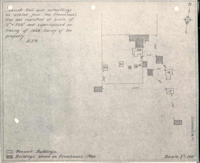 Bassett Hall and outbuildings as scaled from the Frenchman's Map and replatted at scale of 1"-100' and superimposed on tracing of 1928 Survey of the property H.S.R.
 Photostat copy of the Williamsburg Plat in "Williamsburg, the Old Colonial Capitol" by Lyon G. Tyler
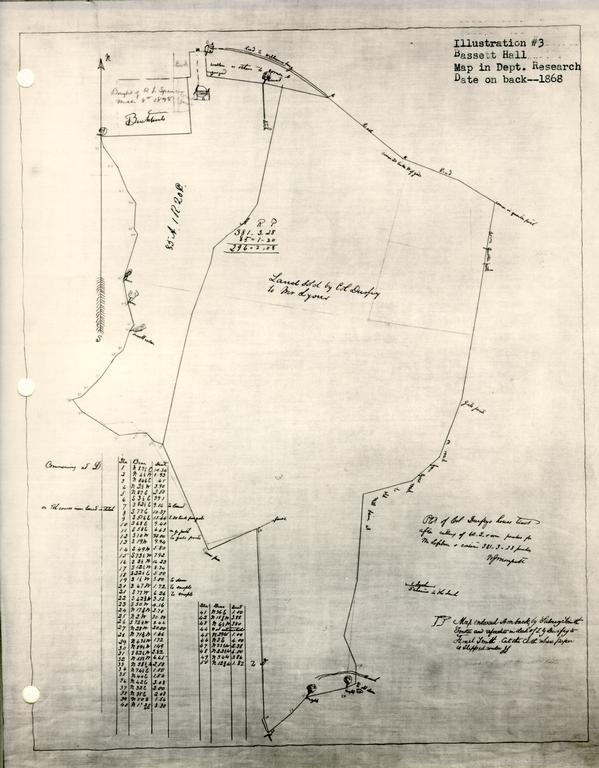 Bassett Hall Map in Dept. Research Date on back—1868
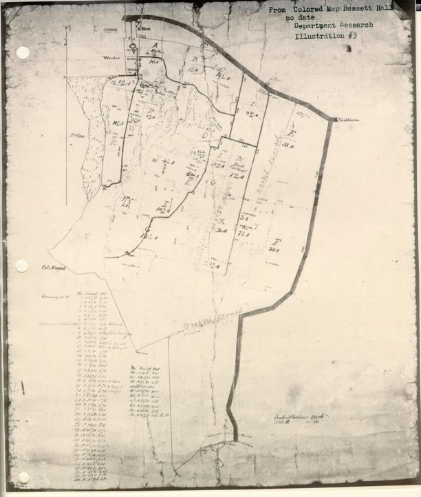 From Colored Map Bassett Hall no date Department Research
To: H. R. Shurtleff, Director of Research & Record
From: H. S. Ragland
Subject: Archaeological Report on Old Foundations found on Bassett Hall Property, Williamsburg, Virginia.
Date: April 2, 1932.
Submitted herewith is an archaeological drawing showing old foundations recently found by excavation on the Bassett Hall property.
Foundation "A", found about 80 feet east of Bassett Hall house, appears to be a very old foundation. The bricks are Palace size, (9"x4½x2½" or 2 5/8"); the bond, English; the mortar, oyster shell. Two periods of construction were found. The original walls are Nos. 1, 2, 3, 4, and 5. In the North East corner, a very large chimney, formed by walls 1, 2 and a part of 3, was found. Its immense size (8' -10" wide x 4' 8½" deep), suggests that the building may have been a kitchen. At the south end of the building at No. 5, another chimney foundation was found. The cellar, enclosed by walls Nos. 8, 9, 10 and 11, was evidently dug out after building was completed, for the footings of the original walls are three feet above the floor. Original walls 3 and 4 were partially undercut and underpinned by walls 9 and 10. The original east wall was not found but apparently wall No. 7 indicates its location, and that it was slightly underpinned by wall No. 8. Cellar steps were found at No. 6. A glance at the plan is sufficient to show that they were built after the chimney.
Walls Nos. 12, 13, 14 and 15 are not bonded to original wall No. 3, and are evidently the foundations of an addition.
Many objects and articles of the colonial period were found in excavating the old well and foundation "A". They were turned over to Mr. Goodwin.
At "B" remains of a double colonial chimney foundation were found, and about 250 yards South east of Bassett Hall house the foundation of an ice house was uncovered. Miss Edith Smith told me that there had been an ice house at that location.
Careful excavations were made at all sites of buildings, indicated on the Frenchman's Map, but no other foundations were found. However, about 250 feet South west of Bassett Hall house, approximately at the location of an outbuilding shown on the Frenchman's Map, fragments of brick and mortar were found, which may perhaps indicate the site of that building.
Herbert S. Ragland
In chg. of Arch. Excavations
HSR/vgl
Illustration #4
BASSETT HALL
AN ABSTRACT OF TITLE made October 26, 1927, by C. M. Hall, Attorney at Law of Williamsburg, Virginia, for William A. R. Goodwin of Williamsburg, Virginia, to a certain tract of land lying partly in the City of Williamsburg and partly in Jamestown Magisterial District, James City County, Virginia, generally known as "Bassett Hall," the same being described in a certain deed dated October 22, 1927, from Edith M. Smith, Alice Colden Smith and Fannie B. Smith to William A. R. Goodwin; said land containing 190 acres.
The records of the City of Williamsburg and County of James City were destroyed in the year 1865, having been burned in the City of Richmond, to which they had been removed for safe keeping during the War between the States. This destruction was complete except as to one Deed Book for James City County, starting the year 1854. This book is said to have been saved by reason of having been lost on the way to Richmond and subsequently found.
By reason of this loss it is not possible to trace titles in the local Clerk's Office back of the year 1854 as to the County of James City, or back of the year 1865 as to the City of Williamsburg. The only way in which same might be traced would be by reference to the Land Books in the City of Richmond, which would indicate only transfers; and such examination is not usually deemed necessary.
1. DEED.
By deed dated in May, 1857, the day being left blank in the deed, recorded November 14, 1859, in James City Deed Book #1 pages 367-8, Goodrich Durfey and Margret W. Durfey, his wife, conveyed to William Lyon land described as follows:
"All of that certain piece and trace of land situate and being in the County of James City known as part of the Bassett Farm, containing by recent survey 298 acres; and bounded as follows: North by lot of Charles Lively and the road from Williamsburg to York Town, East by a public road called Quarter Paths, South by the lands of William Allen, West by the lands of James W. Custis, __________Munford and Goodrich Durfey to the beginning, at Charles Lively's lot."
2. DEED OF TRUST
By deed dated April 3, 1858, recorded November 14, 1859, in James City Deed Book #1 pages 369-70, William Lyon conveyed to J. B. Cosnaham as Trustee the same land acquired by him by the foregoing deed, in trust for the purpose of securing the payment of four bonds or single bills, under seal,…
This deed of trust refers to the foregoing conveyance from Goodrich Durfey to William Lyon, and speaks of the deed as being dated June 19, 1857. The deed is, at end dated June 19, 1857, though at its beginning its date is given as May_____ 1857. This error is of no importance.
3. LAND BOOK.
The earliest available Land Book in the local Clerk's Office for James City County is that for the year 1866, in which, on page 8 at line 12, William Lyon is charged in fee with 298 acres, it being stated that the tract has no name, and that it adjoins N. C. and J. H. Crenshaw, and is one-half mile southeast of the Courthouse. It will be observed that the deeds in Paragraphs 1 and 2 only refer to the land as being in James City County. Later conveyances affecting the whole of Bassett Hall, apparently containing 381 acres, refer to same as being located partly in the City and partly in the County. Apparently the portion conveyed to William Lyon was wholly in the County, as in the earliest available Land Book for the City of Williamsburg found in the local Clerk's Office, being for the year 1865, William Lyon is charged with no real estate. In the same Land Book, at page 3, line 14, Goodrich Durfey is charged in fee with "residence," in the City of Williamsburg; but there is no way of identifying it as being the Bassett Hall dwelling house.
4. WILL
By an un-numbered Will Book marked as follows: "Wills, James City Circuit Court," extending from November, 1869 to November, 1902, there is found on Pages 1 to 3, the will of Goodrich Durfey, and the order probating same…
4The material portions of the will are as follows:
"First. I give to my son, Zachary Durfey, either the Farm on which I now reside, that is to say, the land purchased by me of John Coke, formerly owned by Burwell Bassett, containing about 381 acres, with all the buildings thereon; and valued by me at $8,000.00, or my farm in James City County called `Jockey's Neck,' containing about 500 acres, and valued by me at $5,000.00, the choice to be made by my said son, Zachary Durfey, when he shall arrive at the age of twenty-one.
Secondly. In case my son, the said Zachary Durfey, shall elect the farm first herein named I give and bequeath to him the sum of $2,000.00; or if the last named farm, the sum of $5,000.00 in addition to the real estate which he may so elect, and whatever else he may receive under any subsequent clause of this my will, thus making his portion hereinbefore named $10,000.00 in either case.
****************
Fifthly. I authorize and empower my Executors herein-after named, or such as may execute this will, to rent out my two farms herein named to good tenants (who shall be required to keep them in good order) until my son, the said Zachary Durfey, shall arrive at the age of twenty-one, making choice of them as hereinbefore indicated; then they shall sell the farm not so elected, with any and all the real estate not hereinfore devised belonging to me, at such time and in such manner as they may think best for the interest of my estate, and to apply the proceeds in payment of my debts and legacies."
The sixth clause names the testator's son, Zachary Durfey, and his two daughters, Elizabeth Nimmo Durfey and Margaret G. Lea, wife of Col. John W. Lea, as residuary legatees and devisees.
"Seventh. I appoint my friend, James W. Custis, my son-in-law, Col. John W, Led, and my son Zachary Durfey, whenever he shall arrive at lawful age, Executors of this my will."5
By the codicil dated December 6, 1868, it is provided that on account of the feeble health of James W. Custis, Thomas P. McCandlish is named as one of the Executors in his stead. The codicil further provides that the testator's son, Zachary Durfey, shall be allowed to qualify without security.
5. DEED
By deed dated December 15, 1869, recorded January 4, 1870, in Williamsburg Deed Book #1 pages 193-5, and in James City Deed Book #2 pages 273-5, Zachry G. Durfey, Executor of the last will and testament of Goodrich Durfey, deceased,…conveyed to Israel Smith land described in the said deed as follows:
"That certain tract or parcel of land situate partly in the City of Williamsburg and partly in the County of James City, State of Virginia, called "Bassetts Hall," containing about 381 acres, more or less, bounded as follows: Commencing on the north at the northeast corner of James W. Curtis' lot, thence along the street to the lot occupied by Dr. William S. Morris, thence south to the corner of said Morris' lot, thence east along ditch separating it from said Morris' lot and James Mahone, John Lucas and Charles Lively's lots to the road leading from Williamsburg to York Town, thence along said road to the road called Quarter Paths, thence along last mentioned road to the middle of Tutter's Neck Dam, thence southwest to fence separating it from 'Delks', thence north to fence on the farm, thence southwest' to corner of Munford's fence, thence northwest along said Munford's fence to the corner of Dr. Camm's land, thence along ditch bank and fence separating it from said Camm's land, to the lot formerly owned by R. M. Bucktrout, deceased, thence east to the of said Bucktrouts, lot, and thence north to the beginning, as will appear by reference to the plot of W. I. Morrsett, marked B., and being part of the tract which the said Goodrich Durfey, in his life time, purchased of John Coke and Eliza, his wife as aforesaid, and the same first mentioned in the will of the said Goodrich Durfey, deceased."6
Zachary G. Durfey, as Executor and for himself individually, warranted title generally.
The deed recites that Goodrich Durfey and his wife in their life time conveyed to William Lyon 298 acres, briefly describing same, being a part of the tract of land which Goodrich Durfey purchased from John Coke and wife on November 18, 1845; that William Lyon to secure that payment of $7450.00 as purchase money, simultaneously conveyed said 298 acres to J. B. Cosnahan, Trustee, that Lyon was unable to pay same and agreed in writing with Durfey in 1865 to give the land back to Durfey, who agreed to give up the bonds still unpaid; that no deed was executed to carry out said agreement, that Lyon was still willing to abide by the agreement, that his bonds for purchase money had been given up and received by him, and that he and Sydney Smith, Substituted Trustee in place of J. B. Cosnahan, who had died, (the said Sydney Smith having been substituted as Trustee by order of the County Court entered December 13, 1869), consented and agreed to sign and execute this deed; that Durfey's last will and testament was admitted to probate, then quoting the first and second paragraphs as above given; that Zachary G. Durfey had arrived at the age of twenty-one and had qualified as the sole Executor, and had elected to take the farm Jockey's Neck, and had entered into a contract with Israel Smith to convey Bassett Hall to him.
The deed shows that the purchase price of $8,000.00 was to be payable as $4,000.00 in cash, and the balance in certain installments.
NOTE: It is reasonable to rely upon the correctness of the recitals made in the deed. Those that are material have already 7 been set out, as shown by the records. I consider the deed a good and effective conveyance of the Bassett Hall tract, I do not find of record the plat referred to in the description; though the present owners have in their possession two old plats of the tract which have already been exhibited to the present purchaser.
6. DEED OF TRUST
By deed dated December 15, 1869, recorded January 4, 1870, in Williamsburg Deed Book #1 page 196, and in James City Deed Book #2 page 275, Israel Smith conveyed to Sydney Smith and William S. Peachy the Bassett Hall tract, containing 381 acres as acquired by him by deed of even date for the purpose of securing to Z. G. Durfey, Executor of Goodrich Durfey, the sum $4,000.00 with interest, of which $1,000.00 matured on January 10, 1872, with interest annually from January 10, 1870; and $3,000.00 matured on January 10, 1874, with interest payable annually; as evidenced by single bills of Israel Smith under seal, dated December 15, 1869, for unpaid purchase money.
7. ASSIGNMENT AND RELEASE.
In James City County Deed Book #2 page 451 is found recorded a single bill under seal dated December 15, 1869, made by Israel Smith for $1,000.00 payable to said Durfey, as Executor; together with an assignment by the Executor to Richard W. Hansford dated June 19, 1871. The Clerk's certificate shows that on March 25, 1872, Richard W. Hansford, Assignee, appeared and acknowledged that the $1,000.00 bond had been paid in full.
8. ASSIGNMENT.
By Assignment dated September 10, 1873, recorded September 15, 1873, in Williamsburg Deed Book #1 page 346, Zachary G. Durfey, Executor of Goodrich Durfey, assigned to McRee Swift of New Brunswick, New Jersey, a single bill, under seal, of Israel Smith, dated December 15, 1869, and payable January 10, 1874, and the deed of trust set out in paragraph 6, securing same. The assignment recites that the single bill for $1,000.00 secured by said deed of trust had been paid by Israel Smith.
NOTE: It does not appear that the deed of trust set out in paragraph 6, has been formally released. The release set out in paragraph 7, is sufficient for all practical purposes as to the $1,000.00 bond. The $3,000.00 bond was assigned to McRee Swift as set out in paragraph 8, and while it has not been released I do not think that this would in any way place a cloud upon the title, as our statute prevents foreclosure of a deed of trust later than twenty years from the maturity of the obligation secured. In this instance, more than fifty years has passed since maturity of the bond.
It appears that the $3,000.00 bond is further secured as set out in deed of trust mentioned in paragraph 9 B.
9, A. DEED OF TRUST.
By deed dated February 5, 1872, recorded on the same day in Williamsburg Deed Book #1 pages 285-6, Israel Smith and Rebecca M. Smith, his wife, conveyed to William S. Peachy, Trustee, the Bassett Hall tract, containing about 381 acres, for the purpose of securing to William W. Vest the sum of $1500.00 and interest as evidenced by bond of Israel Smith dated February 5, 1872, payable on or before February 5, 1873.
9NOTE: The lien of this deed of trust does not appear to have been released of record; but as the statutory provision of twenty years for the enforcement of a deed of trust has long since elapsed I do not regard the failure of the records to show release of same as constituting a cloud upon the title.
9,B DEED OF TRUST.
By deed dated September 10, 1873, recorded September 15, 1873, in Williamsburg Deed Book #1 pages 347-8, Israel Smith conveyed to William S. Peachy, Trustee, the Bassett Hall tract containing 381 acres to secure to McRee Swift the performance of Smith's agreement as set out in the deed of trust. Recital is made that McRee Swift bought the $3,000.00 bond secured by the deed of trust set out in paragraph 6, at Smith's request; that the rate of interest is changed from 6% to 8% payable in New Jersey, and that the bond will mature on January 10, 1874.
NOTE: The lien of this deed of trust has not been released, but same is no longer enforcible under the Virginia law as above mentioned.
10. WILL.
The will of Israel Smith was probated on April 14, 1879, which order of probate and the will and codicil are recorded in Williamsburg Will Book #1 pages 311-313. The order shows that the will, dated December 6, 1870, and the codicil dated December 25, 1875, were probated and that Rebecca M. Smith qualified as Executrix with leave given Fannie Belle Smith and Alice Colden Smith to come in and qualify. The will appointed Rear Admiral Charles H. Bell and Rebecca Minturn Smith, the Testator's wife, Executors. The codicil recites 10 the death of Rear Admiral Bell and appointed the said Rebecca M. Smith and the Testator's daughters, Fannie Belle Smith and Alice Colden Smith, as Executors.
The second paragraph of the will is as follows:
"Second. I give to my Executors full power and authority to sell and convey all, or any, of my real estate."
The third paragraph provided that money derived from sales of real estate should be invested by the Executors and the interest paid to his wife during her life and at her death that the proceeds be equally divided among his children upon reaching twenty-one years of age.
The fifth paragraph of the will is as follows:
"Fifth. If my Executors deem it best not to sell my real estate I direct that the profits, rents or income derived from said estate be paid to my wife during her life time, and at her death to be equally divided among my children, if they have arrived at the age of twenty-one years, and if any have not arrived at this age I direct that the share of any such children, be invested at interest to the benefit of such children, or any of them, during their minority but to be paid as far as necessary for their support."
NOTE: The widow Rebecca M. Smith, lived until the year 1911. I am informed that the testator, Israel Smith, was the father of four children by his two marriages, all of whom survived both him and his widow, all of whom reached the age of twenty-one years before the death of the widow. I am of the opinion that these four children, namely: Alice Colden Smith, Fannie Belle Smith, Edith Minturn Smith and Margaret W. S. Bird, nee Smith, sometimes called "Meta S. Bird," became the fee simple owners of the property at the expiration of the life estate of Rebecca M. Smith.
11. DEED
By deed dated October 12, 1882, recorded January 23, 1882 in James City Deed Book #4 pages 324-5, Rebecca M. Smith conveyed to William H. E. Morecock a parcel of land in 11 James City County containing, according to survey, one acre and 1/20 of an acre, being a portion of the Bassett Hall farm. The deed refers to a plat attached thereto, made by Carey P. Armistead, which plat is recorded on page 325.
12. RIGHT OF WAY.
By right of way agreement dated November 24, 1900, recorded December 31, 1900 in James City County Deed Book #7 page 461 Rebecca M. Smith, Alice Colden Smith, Edith M. Smith, Meta W. S. Bird and H. S. Bird, her husband, and Fannie B. Smith granted to the Chesapeake Telephone & Telegraph Company, A Virginia Corporation, a right of way for a telephone and telegraph line, appliances, etc. over and along that tract of land in Jamestown District, James City County, Virginia, near the City of Williamsburg, fronting on the main road leading from Williamsburg to Yorktown, for the purpose of running on that portion of the said tract of land then occupied, or which might thereafter be occupied, as a public road or roads. The agreement was not to be exclusive.
13. DEED.
By deed dated November 7, 1903, recorded December 9, 1903 in James City Deed Book #9 pages 148-9, Rebecca M. Smith, Executrix under the last will and testament and widow of Israel Smith, deceased, Alice Colden Smith, Edith Minturn Smith, Meta W. S. Bird and H. S. Bird, her husband, and Fannie B. Smith conveyed with General Warranty and the usual covenants to Elling P. Strand land described as follows: 12
"That certain tract, piece or parcel of land situate, lying or being in Jamestown Magisterial District, James City County, Virginia, containing by actual survey 112-¾ acres, bounded and described as follows: Beginning at a large cedar tree on the main road leading from Williamsburg to Yorktown and running thence along said road S. 51.25° E. 1.31 chains, thence S. 68° E. 9.40 chains, thence S. 58° E. 6.63 chains to what is known as Quarter Paths road leading to King's Mill; thence along said Quarter Paths road S. 10° W. 32 chains to gate post thence S. 19° W. 9.94 chains along said road, thence S. 49° W. 5.80 chains along said road: thence S. 73.5° W. 7.92 chains along said road, thence S. 72.5° W. 17.44 chains, thence N. 20.75° E. 63.62 chains to point of beginning, the same being a portion of the tract of land called Bassetts Hall conveyed to Israel Smith by deed from Z. G. Durfey, Executor of G. Durfey, deceased, William Lyons and Sydney Smith, Substituted Trustee, bearing date on the 15th day of September, 1869, and recorded in the Office of the Clerk of the Court for the County of James City and the City of Williamsburg in James City Deed Book #2 pages 273-4, to which deed reference is here made."
14. DEED
By deed dated November 12, 1903, recorded January 16, 1904, in James City Deed Book #9 pages 195-6, Rebecca M. Smith, as widow and Executor of Israel Smith, deceased, Alice Colden Smith, Fannie B. Smith, Meta W. S. Bird and H. S. Bird, her husband, conveyed with General Warranty and the usual covenants to Milan Smith 40 acres of the Bassett Hall tract, described as follows:
"That certain tract, piece or parcel of land situate, lying and being in Jamestown Magisterial District, James City County, Virginia, and known as a part of Bassetts Hall, tract supposed to contain 40 acres, be the same more or less, and bounded as follows, to-wit: Commencing at a point on the Quarter Paths road leading to King's Mill where the land hereby conveyed intersects with the land recently conveyed to Elling P. Strand, a course running N. 72.5° E., thence running down said Quarter Paths road to Tutter's Neck Creek, thence along the meanderings of said Creek or swamp to the western boundary of the said Bassetts Hall tract, thence along the western boundary of the said Bassetts Hall tract separating it from Delks to a point where the southwestern corner of said Elling 13 P. Strand's land intersects and thence in a straight line N. 72.5° E. to the point of beginning; bounded on the north by the land of Elling P. Strand, on the east by the said Quarter Paths road, on the south by the said Tutter's Neck Creek, or swamp, and on the west by Delks; the same being a portion of the tract of land conveyed to Israel Smith by deed from Z. G. Durfey, Executor, William Lyons and Sydney Smith, Substituted Trustee, bearing date on the 15th day of September, 1869, and recorded in the Clerk's Office of James City County and the City of Williamsburg in James City Deed Book #2 pages 273-4.
15. DEED
By deed dated January 4, 1913, recorded January 9, 1913, in Williamsburg Deed Book #6 pages 312-13, and recorded January 16, 1913 in James City Deed Book #13 pages 567-8, Meta S. Bird and Hugh S. Bird, her husband, conveyed with General Warranty and the usual covenants of title to Edith Minturn Smith by the following descriptions:
" "All the right, title and interest of the said parties of the first part in and to that certain piece, parcel or tract of land situate, lying and being partly in the City of Williamsburg, Virginia, partly in Jamestown District, James City County, Virginia, generally known as Bassett Hall, and containing two hundred and twelve (112) [sic] acres, more or less, but sold in gross and not by the acre, more particularly bounded and described as follows: On the north by Francis Street, the property of the Morecocks and other property and by the main road leading from Williamsburg to Yorktown, on the east by the lands of L. W. Wales, H. W. Dana and other properties and a lot now owned by the said Edith Minturn Smith; together with the buildings and improvements thereon, the interest of the said Meta S. Bird in the said property hereby conveyed being a one-fourth undivided interest; the same being a part of the land of which Israel Smith died seized and possessed, the same having been conveyed to him by Z. G. Durfey, Executor on the estate of Goodrich Durfey, and William Lyone and Sydney Smith, Substituted Trustees, by deed dated December 15, 1869, and recorded in the Clerk's Office of the City of Williamsburg and County of James City in James City Deed Book #2 pages 273-4, to which reference is here made."
16. OPTION AGREEMENT
By agreement dated March 15, 1916, recorded March 17, 1916 in James City Deed Book #15 pages 416-17, Fannie Belle Smith, Alice Colden Smith, and Edith M. Smith contracted and agreed with James R. Branch that they would within ninety days from the date thereof sell and convey to said James R. Branch certain land at $300.00 per acre, according to survey to be furnished by the grantors, the $500.00 cash payment for the option to apply on the purchase price. The land to which the agreement applied is described as follows:
"All that certain piece or parcel of land together with its appurtenances, being the eastern portion of the property remaining and known as the Bassett Hall tract, beginning at the point on the south side of York or Woodpecker Street where said tract joins the land of Irving S. Whitcomb, and extending along south side of said York or Woodpecker Street in a westerly direction three hundred sixty-five feet, more or less, to a point forty feet east of the western point of said tract at its juncture with said street, extending back southwardly and between parallel lines, the eastern line being the present western line of said Whitcomb property to the southern boundary of said tract, and containing between 30 and 40 acres."
The land owners further agreed to dedicate a street forty feet wide running south from York Street the entire length of Bassett Hall tract and parallel and adjoining the western line of the property contracted to be sold, which street should be for the joint use in common of the two properties.
17. DEED
By deed dated April 10, 1916, recorded May 1, 1916, in James City Deed Book #16 pages 125-6, Fannie Bell Smith, Edith [sic] Colden Smith and Edith M. Smith conveyed to Williamsburg Park Corporation, a Virginia Corporation, with General Warranty 15 and the usual covenants of title, land described as follows:
"All that certain piece or parcel of land lying and being in James City County near Williamsburg in the State of Virginia, containing thirty-six and one half (36½) acres, according to a survey or plat dated the 8th day of April, 1916, made by Bolton, Clark and Pratt, Inc., Civil Engineers of Richmond, Virginia, which plat is attached to this deed to be recorded herewith for the purpose of describing the boundaries of the land hereby conveyed. The lands hereby conveyed being a portion of the residue of the Bassett Hall tract and the said lands are bounded on the north by York Street, on the east by lands of the York Land Company and on the west by the forty foot road which is hereby set apart and granted as a easement of way by the parties of the first part to the parties of the second part, its successors and assigns, for the joint use of the owners of the residue of the said Bassett Hall tract, and the owners of lots and parcels of land hereby conveyed. The said road forty feet in width is to be at all times open its full width and length as shown on said plat."
On page 126 of D. B. 16, is recorded the plat referred to showing that the land conveyed is thirty-six and one half acres exclusive of the road reserved, and further showing the road between the unsold Bassett Hall land and the parcel conveyed.
NOTE: It will be observed that the land conveyed by deed set out in paragraph 17, is without doubt the same land conveyed by the option agreement set out in paragraph 16, though James R. Branch did not untie in said deed. It is indicated, however, by a deed of trust from Williamsburg Park Corporation to E. Lorraine Ruffin, Trustee, dated April 17, 1916, recorded in James City Deed Book #16 pages 127-31, from the quoted resolution of the Board of Directors of the grantor Corporation that said Corporation took over as its obligation an agreement of Garrett & Co. with James R. Branch as to the purchase of said land.
18. SEWER RIGHT OF WAY.
By right of way agreement dated June 3, 1921, recorded August 18, 1921 in Williamsburg Deed Book #9 pages 216-17, Edith M. Smith and Alice Colden Smith conveyed to the City of Williamsburg a right of way over, under and through property 16 therein described for the purpose of constructing, operating maintaining and repairing a sewer main…
19. CURRENT LAND BOOKS.
In the Land Book of the City of Williamsburg for the year 1927, page 14, line 30, Israel Smith and E. M. Smith Estate is charged in fee with "House and lot, Bassett Hall, East Francis Street," with land and buildings. In the Land Book for James City County for the year 1927, page 8, line 19, Israel and E. M. Smith Estate is charged in fee with a part of Bassetts Hall containing 132½ acres.
NOTE…
20.
…
CERTIFIED,
C. W. Hall, Attorney at Law
Illustration #5
Letter of A. P. Upshur to B. Tucker Esq., WilliamsburgVaucluse Jany 27 1840
Dear Judge
I received last night, your letter of the 13th & at the same time, one from Christian upon the same subject, dated 12th … I have given the night to reflection on the subject of Galt's1 land, & have come to the conclusion to take it at $10000. I expected to get it for less, but as it seems to be considered worth that, I will agree to give it. I confess however, that it is not without some misgivings, that I burthen myself with such a debt, at my time of life …. At all events, if I buy Galts & should not sell this, I can sell that if it should become necessary. As I shall have to set it up with the necessary labour, I shall have occasion for all the cash I can raise. Cole will bear this in mind, & obtain as long credits as he can. As he & Christian were both present when Christian undertook to make the purchase for me, they will of course, move together in the matter. John Coke is waiting my determination, & therefore I should be glad if you would communicate it to him. I speak of 10 000 $ as the price, because both you & Christian seem to think that it can certainly be bought for that … But I do not mind a few hundred either way …
Letter of A. P. Upshur to B. Tucker Esq WilliamsburgVaucluse Ap 5 1840
My dear Judge
…
As to my Galt business you will perceive from a letter of mine written since that, to which yours is a reply, that the course you have pursued, is exactly according to my wishes. I hope I shall succeed in reconciling my family to the change. It is probable that they will not go with me in May …
Letter A. P. Upshur to B. T. Tucker Esq. WilliamsburgRichmond Nov 28 1840
Dear Judge
…
On my arrival at Jas: Town, I met Goodrich Durfey, who proposed to purchase my land. I had offered it to Tyler, (who requested me to give him the refusal) at 12 000 $ payable by annual instalments, & told Durfey that I could not give him a positive answer til Tyler should decide; but that I would not wait many Days for that. I wrote to Durfey from Petersburg, offering the land to him for $12 000, he to relieve me from Vest & Coke's mortgages, & to pay me the balance with interest at any time he chose, within reason; & telling him that I should be ready to close the bargain with him, by the time I could receive his answer, whether I should have heard from Tyler or not. I have not heard from either of them … I am determined to sell, although I would greatly prefer to retain the land …. I am unwilling to burthen myself with such an amount of debt [this debt and other] I am otherwise determined to sell, provided I can get cost. The actual cost to me was about $10500, & if I can do no better, I am willing to take what will be equivalent to that sum with interest from the 5th of May, 1840, to the time of sale …
A. P. Upshur
To-B. Tucker Esq. WilliamsburgVaucluse June 17 1836
Mr Dr Sir
I have just received yours of the 3d Inst I had heard before, of the purchases & sale of Col Basset's land, & did not doubt that there was good reason for your not retaining it for me. You judged rightly, that I could not conveniently pay the whole sum at once, particularly as I am to run a race through the C of Appeals for the large debt I have recently recovered in Staunton. I am very sorry indeed, that it has so turned out…
Abel P. Upshur
To- Beverley TuckerVaucluse March 17t 1837
My dear Sir…
Your suggestion about my removal to Williamsburg, is not a new idea to me. I have mediated…and one of my chief inducements was, that I should have the counsel & assistance of yourself…
A. P. Upshur
To B. Tucker Esq. WmsburgVaucluse July 28 1838
My dear Sir
I should delay yet a little longer, my reply to your letter, if it was not for that part of it, which relates to Doctor Peachy's land. As he has an offer for it, & is reserving it for me, I ought not to leave him any hopes in uncertainty as to my wishes. Please say to him that I do not wish to purchase.…
A. P. Upshur
To- B. TuckerVaucluse Novr 15th 1838
My dear Judge,
…
Is there any better mode of making a few thousands easily than by planting the morus multicantis? There seems to be a growing disposition in the country to engage in the making of silk, and the probability is that the demand for the mulberry will not decrease for many years. If you agree with me, I propose to you to take one half my purchase of the vineyard and engage in the culture of that tree. We shall require but a few acres of the land, and it is probable that the balance of the estate will rent out for enough to cover all our expences except the cost of the plants. Think of this and let me know the result.…
A. P. Upshur
To-B. Tucker Esqr WilliamsburgVaucluse January 14th 1839
Dear Judge
…
I have received a letter from Col Mc.candlish, written in behalf of William U Delk, expressing his desire to lease, or rent the Vineyard, for farming purposes only. By the same mail, I also received a letter from Captain Charles Lively, expressing the desire of himself, and his co-tenant Jarvis, to remain on the land, upon the same terms as heretofore. I have written to these men, referring them to you. Will you do me the favour to make with all, or either of them, such bargain as you think proper.…
A. P. Upshur
[To-] B. Tucker Esqr WilliamsburgVaucluse Feby 25 1839
…
I am glad to set off with Christian. The land I know, is intrinsically worth twice what I gave for it, if the title were clear; but it is not clear. The present condition of the land is such, that I could not make any thing from it, without expending 1500$ in buildings & as much more in labour, (exclusive of slaves,) utensils & stocke. If I should lose the land, I should probably lose the improvements, and should certainly lose a great deal in utensils and stock. … I think I do well to be off. The interest is enclosed, which please deliver to Christian…
A. P. Upshur
To Judge B. Tucker WilliamsburgNorfolk Decr 4 1840
Dear Judge
…
I have this moment, received a letter from Durfey, declining my offer. He says my terms are so much more than he is willing to accept, that he deems it unnecessary to make my any offer, but he also says that he is anxious to have the land & will give as much as any one else will give….…Remember that the property cost me $10500 on the 5 May last, & I shall be very glad to get my money back with interest, or without a serious loss.
A. P. Upshur
[To] B. Tucker Esq WilliamsburgVaucluse Ap 10 1841
My dear Judge
…
Your letter has given the coup de grace to my already expiring hopes, in regard to the sale of my land. Well, I have only to look out for the ways & means of completin my payments for it….
A. P. Upshur
[To] B. Tucker Esq WilliamsburgNorfolk June 10 1841
Dear Judge
…I have prepared an advertisement to be inserted in the Beacon of this place & the Whig of Richmond notifying all the world that my Wmsburg land is for sale…If I can get within five or six hundred dollars of the actual cost, I shall be content….
A. P. Upshur
[To] B. Tucker Esq. WilliamsburgVaucluse July 28 1841
Dr Judge
…
I would greatly prefer to sell, & am still in hopes that a purchaser will offer. This however, is so improbable, that I will not lose a good tenant by waiting for it. I am wholly unable to say what sum it will or ought to rent for. Mccandlish told me that he did not think it would command more than 300$, but surely that must be a mistake However, get what you can…
A. P. Upshur
[To] B. Tucker Esq WilliamsburgVaucluse Aug 7t 1841
Dear Judge
…Entre nous, I have for sometime, feared that I should be compelled to encounter such a sacrifice with this Wmsbg land. I cannot pay the mortgages, if called on to do it shortly, so that, it depends very much upon Cole & Coke, whether I am to be ruined or not°I will hold on a little longer…
Appendix #6
List of pictures on file of
BASSETT HALL
- 1Bassett Hall, north elevation, photograph #N1532
- 2Bassett Hall, Francis Street, #1491 - photostated from original in the library of the New York Historical Society
- 3Bassett Hall, Francis Street, photostated from photograph in Harpers New Monthly Magazine, p. 944 [Article bound in vol. in Wm. & Mary Archives entitled "The College of William & Mary," Vol. II.]
January 23, 1951
To: Mr. CampioliFrom: A. P. Middleton
Re: Report on Bassett Hall
Attached herewith is a report on Bassett Hall prepared by Mary A. Stephenson.
A. P. M.
A. P. M.
RR 1004
ACK 4/10/5
Footnotes
Errata
p.14, first item: "and 1 (2)" added after "#1."